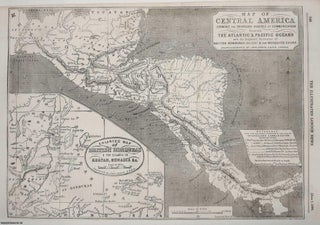
Map of Central America shewing the Proposed Routes of Interoceanic Communication between the Atlantic & Pacific Oceans and the Disputed Territories of British Honduras (Belize) & the Mosquito Shore. Drawn & Engraved by John Dower, F.R.G.S., London. The map includes trans-Isthmian options, showing the different proposed canal routes. An original page from The Illustrated London News, 1856.
London: Illustrated London News, 1856. First Edition. Disbound. A single page. Note; these are original pages separated from larger volumes, not reprints or copies. Size: Page size 26 x 40 cms. . Quantity Available: 1. Category: Illustrated London News; Canals & Waterways; New Arrivals; Inventory No: 369642. This item may..... More